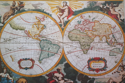
Nova Delineatto Totius Orbis Terrarum Per Petrum Vander Aa. (18th century)
'Journey all over the universe in a map, without the expense and fatigue of traveling, without suffering the inconveniences of heat, cold, hunger, and thirst.'
Miguel de Cervantes
Don Quixote (1605-15).
I have always been fascinated by old maps. Their beautifully drawn, hand coloroured details are pleasing to the eye. At the same time antique maps illustrate bygone times in a stimulating way. One also must admire the skill of the famous mapmakers who were able to produce quite accurate maps at a time when there were no GPS or other advanced technical instruments at their disposal. Of course, even the best mapmakers - like Gerard Mercator and Abraham Ortelius - tooks certain liberties, as Mathew Lyons points out in his very readable little book "Impossible Journeys":
"Not content to rely on gossip they picked upon quaysides, or scraps of third-hand information allegedly culled from antique texts, the mapmakers had no ethical problems when it came to inking in areas on their maps that they thought ought to exist. While our understanding of mapmaking would usually be confined to the careful marking of the known, medieval and Renaissance cartographers had a rather more generous conception of their role.They were philosophical geographers. Worse, perhaps, they were theoretical philosophical geographers. They liked to extrapolate, on the basis of fashionable theory, what might be out there, still undiscovered. While some were happy to let unknown coasts stay unmarked - the unbroken lines of peninsulas, points and coves tailing off, like loose threads or trains of thought, in open space - others had no apparent qualms about setting down their ideas and sending them out into the world, as if to say `This is so.´
Lyons goes on to name some interesting examples of early "creative" mapmaking, like e.g. Terra Australis Incognita (corresponding to Antarctica), which figured in different forms in many famous maps, although no human being is known to have seen Antarctica before 1820.
Detail from map of the Turkish Empire, 1606
Map of Moscow, 16th century
PS
If you are interested in learning more about old maps, the Perry-Castañeda Library Map Collection at the University of Texas at Austin is a good place to start.


No comments:
Post a Comment